MIR: regridding octahedral GRIB fieldlist
This example shows how to interpolate GRIB data defined on an octahedral reduced Gaussian grid using the mir backend. We will also see how to inspect and plot the resulting data and how to convert it to xarray.
To make this notebook work earthkit-data and earthkit-plots have to be installed. The data will be represented as a :ref:~earthkit.data.core.fieldlist.FieldList`.
Regridding
We perform the regridding with the regrid() method.
[1]:
import earthkit.data as ekd

import earthkit.geo as ekg

# Get octahedral reduced Gaussian GRIB data containing two fields.
ds = ekd.from_source("sample", "O32_t2.grib2").to_fieldlist()

# the target grid is a global 5x5 degree regular latitude-longitude grid
out_grid = {"grid": [5, 5]}

# perform interpolation for each field and add results
# to a new fieldlist stored in memory
r = ekg.regrid(ds, out_grid=out_grid, interpolation="linear")
Cache file /tmp/cache/mir/weights/18/linear/R32-98df937a38e9495da1d994b0eeb43e8b-87.8638:0:-87.8638:357.5/LL-5x5-90:0:-90:355-0a5644c49e38d4e140050e3165e32615.mat does not exist
Creating cache file /tmp/cache/mir/weights/18/linear/R32-98df937a38e9495da1d994b0eeb43e8b-87.8638:0:-87.8638:357.5/LL-5x5-90:0:-90:355-0a5644c49e38d4e140050e3165e32615.mat
CacheManager creating file /tmp/cache/mir/weights/18/linear/R32-98df937a38e9495da1d994b0eeb43e8b-87.8638:0:-87.8638:357.5/LL-5x5-90:0:-90:355-0a5644c49e38d4e140050e3165e32615.mat
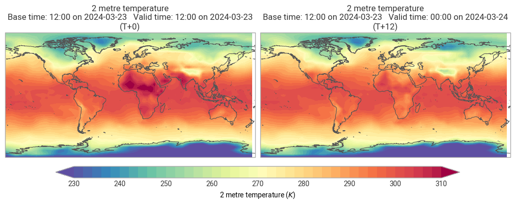
Plotting the results
We use earthkit-plots to visualise the results.
[2]:
import earthkit.plots as ekp

ekp.quickplot(r)
[2]:
<earthkit.plots.components.figures.Figure at 0x134b83620>
Converting the results to xarray
[3]:
r.to_xarray()
[3]:
<xarray.Dataset> Size: 44kB
Dimensions:    (step: 2, latitude: 37, longitude: 72)
Coordinates:
  * step       (step) timedelta64[ns] 16B 00:00:00 12:00:00
  * latitude   (latitude) float64 296B 90.0 85.0 80.0 75.0 ... -80.0 -85.0 -90.0
  * longitude  (longitude) float64 576B 0.0 5.0 10.0 15.0 ... 345.0 350.0 355.0
Data variables:
    2t         (step, latitude, longitude) float64 43kB ...
Attributes:
    Conventions:  CF-1.8
institution: ECMWFWriting the results to disk
Write the resulting fieldlist to disk:
[4]:
out_file = "_res_O32_to_5x5.grib"
r.to_target("file", out_file)
[ ]: